RoMaS
The RoMaS software integrates road marking design software in a GIS environment (Geographical Information System). This integration bestowes upon the user a tool that enables her to design and manage road markings on a digital map in a simple and correct manner. Per road marking, all relevant data are saved in a database, making them available for further analysis at any point in time. This tool enables you to map, manage and maintain horizontal sign posting (road markings).
The road markings are directly designed in a GIS environment and linked automatically to the road marking polygon drawn on the digital map. RoMaS is a software extension fully integrated in the ArcGIS GIS software.
Overview
Road Markings Layer
The RoMaS extension draws the road markings in a GIS polygon layer (ArcGIS Shape files or ArcGIS File Geodatabase). As a result, the polygon layer is a real and true rendering of the road markings by means of polygons. Attributes of this polygon layer enable you to save a certain number of characteristics in the linked database.
Road Marking Types
The RoMaS extension exists of a toolbar that gives you access to the following base types of road markings:
Solid line, Intermittent line, Bicycle path, Pedestrian/Bicycle crosssing, Stop line (solid or triangular), Speed hump, Channelizing island, Bus stop, Icons (disabled persons, bicycle, school, ...), Presorting facilities, ...
Parameters
Each road marking base type gives access to a screen which allows the user to set the different parameters as (s)he sees fit. These customized parameters can be saved in a base database.
Manufacturing data
A certain number of relevant data of the road marking are saved in a database that is linked to the road markings layer:
- Type of road marking: Line-Proximity road markings, Bicycle path, Crossing, ...
- Road marking colour
- Road marking material
- Road marking surface
Example
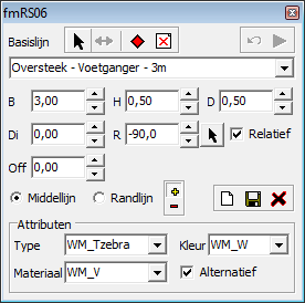
The Pedestrian Crossing base type screen:

- Various parameters can be set by the user, like width, height, off-set, angle, etc.
- Attributes of the road marking polygon can be set.
- Way of working: Select as a base line either the centre line or the border line of the road marking (this base line is to be created beforehand) and have the polygon of this base line created by the application.
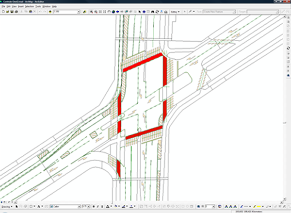
Result:

